
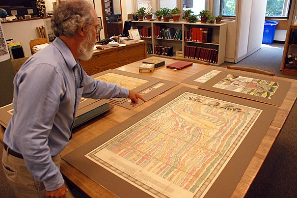
Research librarian Joseph Garver examines an early 18th century chart depicting various empires in a “river of time.”
Peter Reuell/Harvard College Library
Arts & Culture
Off the beaten path
To the land of drunkards and beyond in Map Collection’s exhibition
When he set out to develop the first classification system for maps, the Rev. Henry Clay Badger, Harvard Map Collection curator from 1889 to 1892, used geographical categories — continents, nations, regions, cities, and so on. Though the system worked well, challenges remained. How would maps of fictional or imaginary places be classified? Where would maps of timelines and genealogical tables fit?
A new exhibition, “Rev. Badger’s Misfits: Deviations and Diversions,” opening today (Sept. 8) at the Harvard Map Collection, asks viewers to consider some of these “cartographic curiosities.”
Among the exhibition highlights is a 1730 German map portraying human vices as separate kingdoms, with Latin names such as Magni Stomachi Imperium, or the Empire of the Big Stomachs, and Litigonia, or Land of the Litigious. Town names are in idiomatic German. The land of the drunkards contains towns such as Stolpen (Stumble), Schlampen (Guzzle), Hundsrausch (Dog Drunk), and Schickihnheim (Send Him Home).
Other items in the exhibition include a facsimile of Sebastian Adams’ “chronological chart of ancient, modern and biblical history” — a 24-foot-long timeline running from 4004 B.C. to 1881 — and an 1834 map satirizing Dutch university life, in which students must pass through the Mountains of Mathematics before entering nations representing scholarly disciplines such as philosophy, medicine, and literature.
Many of the items might not even be maps, strictly speaking. As an example, research librarian Joseph Garver points to an early 18th century chart depicting the rise and fall of various empires as streams in a “river of time.”
“Certainly, this is not a geographical map,” Garver said. “It’s a chronological map. For cartographers, it was an interesting challenge to portray the passage of time, because, in a way, it’s representing space as well. By tracing the various empires, they were illustrating how long it lasted, and the territorial expanse it covered as well.”
The exhibition was inspired, Garver said, by requests for unusual items.
“From time to time, patrons come in asking for items that don’t fit into the old Badger system,” he said. “That prompts me to take out one of the folders to see what is in it, and it’s always fascinating material.”
“Rev. Badger’s Misfits: Deviations and Diversions” will be on display in the Harvard Map Collection in Pusey Library through Jan. 5.