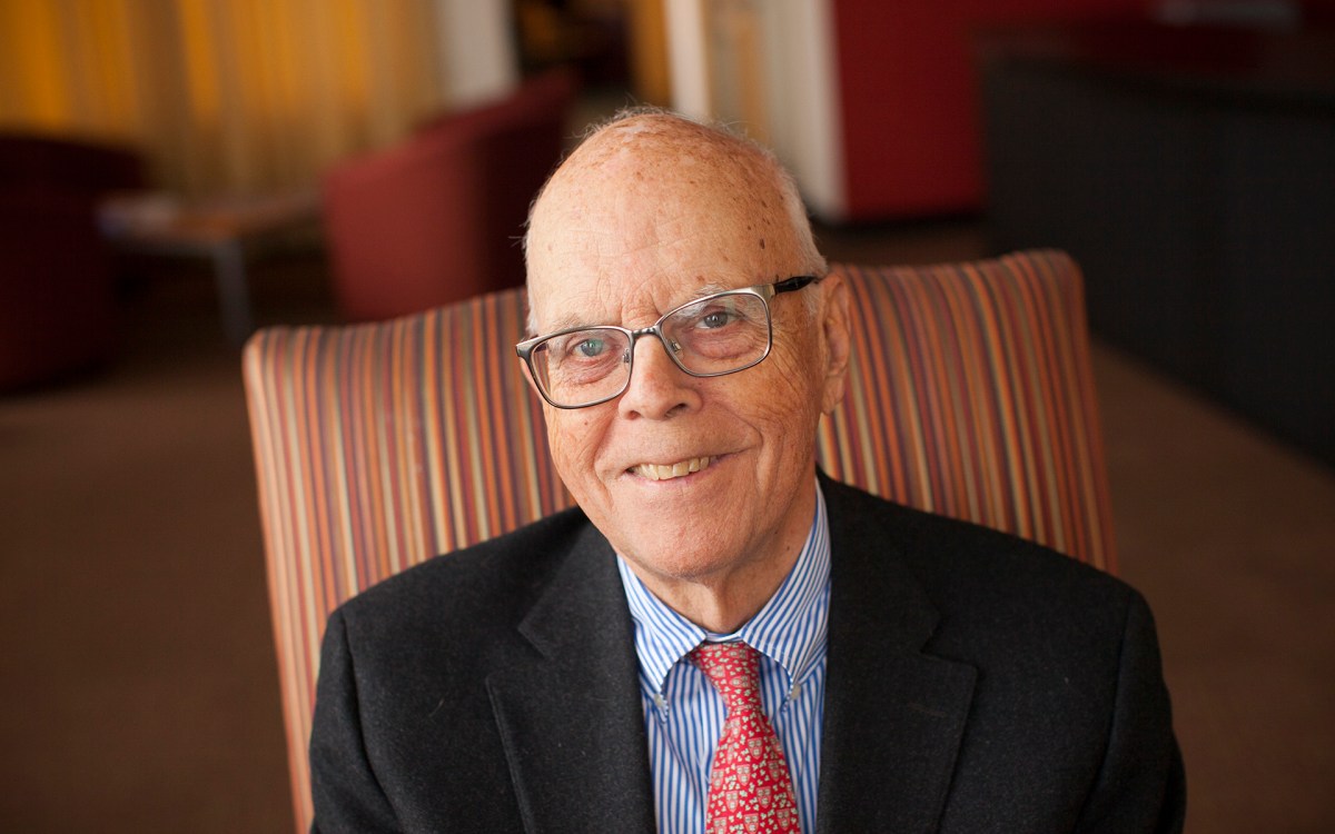


“The river was foul,” said Harvard crew coach Harry Parker when describing the Charles upon his arrival in 1960. “Now, it’s wonderful.”
Rose Lincoln/Harvard Staff Photographer
Campus & Community
A river runs through it
Harvard’s long and complex ties to the Charles
When Harvard crew coach Harry Parker first arrived on campus in 1960, a fetid smell still draped the Charles River from upstream industries. Tires and other debris washed downstream after heavy rains. A simple fall into the water required a tetanus shot.
“The river was foul,” said the now-legendary Parker, who has spent six days a week on the open water for half a century. “Now, it’s wonderful.”
The University today enjoys a simmering romance with the Charles, whose tree-lined vistas help to shape Harvard’s iconic image. There is the sweep of calm water, a lone rower in a slender scull, lush shoreline trees, and handsome brick buildings just beyond, their domes sparkling in the sun — components that make up what Anita Berrizbeitia, a professor of landscape architecture at the Harvard Graduate School of Design (GSD), calls one of the most picturesque college vistas in the world.
Meanwhile, Harvard’s scholars have a growing interest in the winding Charles as a living laboratory. But this inviting picture — the river as image, the river as classroom — was a long time coming.
Getting from foul to fabulous took a century. Before the transition, the Charles was Harvard’s humble back door, functioning as a kind of loading dock for food, coal, and lumber. Sewage was rampant – a legacy of pollution that eventually closed the river to swimmers in 1955. Fifty years and $500 million later, the river is nearly clean except for its sediments, though swimming is still officially banned.
How much times have changed will be evident this weekend (Oct. 23-24) during the annual Head of the Charles Regatta. Since its start in 1965, it has become the world’s largest two-day rowing event, attracting more than 8,000 competitors and upwards of 300,000 spectators to the river bisecting Harvard.
From the area’s settlement in the 1630s, the Charles represented sheer practicality for Cambridge and Harvard, a means of transport and trade. The river’s daily tides provided assurance that Cambridge — once the prospective fortified capital of the Massachusetts Bay Colony — was protected from oceangoing invaders. “This was a defensible space,” said Charles Sullivan, executive director of the Cambridge Historical Commission and author of a history of Harvard Square.
“Harvard and the town of Cambridge took the high ground” in the 17th century and built safely above the tidal waters, said architecture historian Karl Haglund, author of the seminal “Inventing the Charles River” (MIT Press, 2003). The relationship with the river was “not very formal.”
That practical relationship eventually became shaded with embarrassment. After 1875, upriver industries turned the Charles and its vast salt marshes into a polluted waterway that at low tide was an expanse of fetid mudflats.
“It was something you stayed away from, except for transport,” said Watertown landscape architect Gary Hilderbrand, a longtime adjunct GSD professor.
Then came a historic shift. Around 1900, Harvard officials looked down from the School’s high, well-drained ground and began to see the workaday, worn-out Charles for what it could be: a public space with civic and aesthetic value. That change was “a recognition that the river was vital to life in this biophysical region,” said Hilderbrand.
During this transition, he said, “Harvard comes up very beautifully.” By 1913, the Larz Anderson Memorial Bridge, high-arched and handsome, had replaced a ramshackle wooden drawbridge. The coal wharves had vanished, and a boulevard of trees filled in the grim nakedness of the riverbanks. Harvard’s back door was becoming its front door.
Now, Harvard and the Charles have reached another transitional time, one in which designers and other scholars imagine the river as more than a reliable aesthetic feature. Experts increasingly envision it as a classroom, as the new center of campus life, as a way to enhance civic engagement.
The evolving tale of Harvard and the Charles may yet become a model for how American universities can move from their historical inwardness to a modern interaction with the world beyond their gates. “Universities begin as enclaves [that are] not implicated in city-making,” said Berrizbeitia. But over time “they become more and more entwined with the city as both grow.”
“The Charles could become a model for other urban rivers,” said Renata Von Tscharner, founder and president of the Charles River Conservancy, which has offices in Harvard Square.
Tidal Centuries
The Charles was not always so placid. Until 1910, much of it was not a river at all, but a vast estuary with daily 9-foot tides — a place of salt marshes that made up a dynamic liminal space, half water and half land.
Early Cambridge was built in an enclosure. Where there was no water or marsh, there was thick, forested wilderness. The bordering marshes reached all the way to present-day South, Quincy, and Brattle streets. Around the time Harvard was founded, what is now Garden Street was called the Highway to the Great Swamp, the marshy environs of Fresh Pond. A creek ran through Harvard Yard.
Five of the original eight streets in Cambridge (then called “Newtowne”) referred to the village’s riparian, aqueous character. Mt. Auburn was Spring Street. Brattle Square and part of Eliot were called Creek Lane. Dunster was Water Street, the original center of village commerce because it led to a riverside wharf. Holyoke was Crooked Lane because it had to jog to avoid a creek.
“Water used to pretty much surround the old part of the campus,” said historian John Stilgoe, “and we don’t remember those days.”
Stilgoe, Harvard’s Robert and Lois Orchard Professor in the History of Landscape, is a student of little-seen remnants of old times, and a champion of outdoors learning. He invites Harvard Square strollers to look for a fragment of an 18th century seawall on Winthrop Street, where oceangoing ships once tied up along “the coast of Harvard.”
From 1631 onward, the Charles was a key means of transporting goods upstream. The first levy that settlers paid, 30 English pounds, was to enlarge and deepen a natural creek so ships could dock. Later, Harvard owned its own sloop, which transported firewood from Maine.
Pollution, then vision
By the mid-19th century, the river had become a handy sewer for industrial waste, including blood and animal parts from slaughterhouses upstream. (Abattoirs got their start on the Charles in 1775, at a stockyard constructed to feed American troops during the Revolution.)
By the Civil War period, the Charles had become an actual sewer. Private systems for human waste lined its sides, and at low tide the sewage would dry up and blow into the air. “It was a totally noxious situation,” said Sullivan. “It was not an environment conducive to development.” The state began installing interceptor sewers in the 1880s.
The Charles was “unsightly, unattractive, and unhealthy” — all the more reason for Harvard to surrender the lowland riverbanks to industry, squatters, and immigrants.
“The Charles was more or less the service entrance to the University,” said Berrizbeitia. “There were coal plants [and] all the things you don’t want to see.” She said these industrial realities tended to increase Harvard’s sense of itself as an “inward-looking enclave.”
But the embattled Charles was nonetheless at the same time becoming the focus of a rising regional dialogue about the future of cities, in particular the fate of natural settings in an urban environment.
At the center of such discussions was Charles Eliot, Class of 1882, a visionary landscape architect, protégé of Frederick Law Olmsted, and son of Harvard President Charles William Eliot. The son’s ideas inspired the 1891 Trustees of Public Reservations — what is now the oldest regional land trust in the world — and accelerated the rescue of the Charles.
By the late 1890s, Harvard set its sights on expanding across the river, and commissioned plans to officially connect Harvard to the river. (Among them was an Olmsted drawing of a tree-lined promenade connecting the river to Widener Library, what Berrizbeitia called “a very direct and beautiful lane of connectivity.”)
By 1903, Harvard Stadium had been built across the river in Allston, its horseshoe shape opening directly to the Charles.
A year before, a group of Harvard alumni, led by Edward Waldo Forbes, Class of 1895, had formed Harvard Riverside Associates and began buying property between the Yard and the Charles. That set the stage for the University to “open up and relate to the river,” said Berrizbeitia, who is researching the lessons that Charles Eliot brings to modern urbanism. “He was so avant-garde,” she said, that she often finds herself asking, “What would Eliot do?”
Some of the river’s rising appeal at this time came through engineering. After 40 years of debate, the Charles was dammed in 1910, shutting out the sea’s salt water and eliminating the tides. Overnight, the vast, porous basin was transformed into “a big, long lake,” said Berrizbeitia. The river became a shimmering mirror in which Cambridge and Boston could see themselves anew.
The dams “resculpted” the river, said Sullivan, and accelerated proposals to line it with public parks and promenades. The city of Cambridge claimed all of its riverside land for public use in 1892, and hired Eliot to design the landscape. In 1894, an experimental fragment of the Charles River Road (now Memorial Drive) was constructed near Eliot House. The road was completed in 1914.
The taming of the river made it possible for Harvard to embrace the Charles as an aesthetic analog to the streams that have made their placid way through traditional English universities since the Middle Ages.
Troubles remain
As Harvard was awakening to the river’s appeal, the foot of Boylston Street (now JFK Street) was still a jumble of trolley yards, smokestacks, and wharves stacked with coal.
Even a generation ago, signs of that industrial past remained. The trolley yards were only torn up in 1977 during construction of the Harvard Kennedy School, and the Charles itself remained polluted, until governments pooled funds to clean it.
Von Tscharner believes there has been so much progress that it’s even time to bring back swimming. The river is only dark because of upstream tannins, she said, and suggested, “Think of it as tea.”
Throughout these shifts, there has been crew, the river’s signature sport. Harvard entered its first informal boat races on the river around 1844, and the first official crew team slipped a boat into the water in 1852. Harvard’s relationship to the river remains crew-centric, said Parker.
Harvard’s embrace of the river around 1900, said Sullivan, was foretold by “a turning to the river by the undergraduates,” who in the 1850s built and financed their own boathouses.
Future Perfect?
Moving forward, Harvard wants a relationship with the Charles that goes beyond crew and aesthetics. For example, courses involving the waterway — in history, art, and landscape design — have made their way into the curriculum in the past decade. The transformation of the Charles has itself become a source of scholarship.
“It’s a fantastic case study of how natural systems have been transformed to become social spaces,” said Berrizbeitia. She called Harvard Yard the University’s old cultural center, and the Charles its new center.
Pierre Belanger, a GSD associate professor of landscape architecture, sees the Charles as being at the core of what should become a renewed civic-academic engagement in the region’s ecological health. Belanger said, “We’re right at the edge of a moment, asking: What do we do?”
The region’s problems also can be viewed a microcosm of a rapidly urbanizing world. Against that backdrop, the river could become an instructive “arena for cooperation,” said Belanger, and a rich field site for research and experiments.
Last year, he and his students designed a river ice skating park at the Eliot Bridge. “The point was to show we can help, at the very beginning, in a small, modest way.”
It is time, Belanger said, for design schools to move “beyond aesthetic imperatives.”
In fact, there’s a book that does so, called “Bringing the Harvard Yards to the River” (Harvard Design School, 2004), a slender volume edited by the GSD’s Joan Busquets, the Martin Bucksbaum Professor in Practice in Urban Planning and Design. In it, the contributors imagined turning parkways into promenades, digging pedestrian tunnels, and even building a midriver recreational island.
Each of the ideas shared a goal, Busquets wrote, “the importance of establishing a better connection to the Charles River.”