
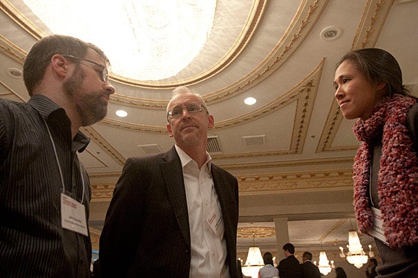
John Crowley (from left), Gregg Greenough, and Jennifer Chan authored the report “Disaster Relief 2.0,” released on March 28. The report looks at the new information flows, such as the Haiti OpenStreetMap, that result from recent technological advances.
Kris Snibbe/Harvard Staff Photographer
Nation & World
Tapping the ‘information fire hose’
Report says new techniques can boost aid in natural disasters
Last winter, 640 volunteers around the world created a map of Haiti from scratch in just two-and-a-half weeks. The monumental undertaking was spurred by the earthquake that reduced large parts of the nation’s capital to rubble and by the desperate need for accurate maps for the hundreds of aid organizations responding to the crisis.
The volunteers worked largely remotely, making changes to the Haiti map on OpenStreetMap, a web-based depiction of the world that people can edit, similar to the way that text-based content is altered in Wikipedia.
“Six hundred and forty mappers made 1.4 million edits in two-and-a-half weeks. They literally mapped the country,” said John Crowley, research coordinator for crisis dynamics for the Harvard Humanitarian Initiative (HHI) and a 2008 graduate of the Harvard Kennedy School.
Crowley and Jennifer Chan, an HHI associate faculty member and assistant professor from Northwestern University, authored a report released Monday (March 28) on the issue. “Disaster Relief 2.0” looks at the new information flows, of which the Haiti OpenStreetMap is an example, that result from recent technological advances. The report, commissioned by the U.N. Office for the Coordination of Humanitarian Affairs, the United Nations Foundation, and Vodafone Foundation Technology Partnership, and written by a team at HHI, examines both the current use and potential future impact of advances in technology on humanitarian disaster response.
“Disaster Relief 2.0” says modern technology enables two new major information flows that could overwhelm workers dealing with a major emergency in the field, but that could also, if properly handled, become an enormous asset.
“We have the opportunity here to take advantage of the situation. … If we do it, we can adapt faster, respond faster, and respond more efficiently,” Crowley said.
The two information flows come from very different populations, according to the report. In the first case, for people living in the disaster zone, the rise of cell phones and social media and their rapid adoption even in poor countries means that those affected can communicate with responders in ways they could not before — relaying problems, like texting that you’re trapped beneath rubble — and crowd-sourced field conditions that can aid responders’ decisions.
The second group is a volunteer and technical community that has arisen in an informal global network. These people, often expert in their fields, assist efforts such as OpenStreetMap, often on their own time, and create resources that may provide information otherwise unobtainable by relief workers.
The problem, Crowley said, is managing data flows from what the report describes as “information fire hoses,” sifting out the useful data, and doing so in ways that enhance decision-making and response rather than overwhelming them. The report suggests that discussions and forums should determine what data is most useful and what format would be most accessible to those in the field.
“We are awash in data, and that is a key point,” Crowley said. “We need a framework to help the system learn how to deal with this new information.”
Specifically, the report recommends creating a neutral forum where areas of agreement and conflict between the humanitarian community and the global volunteer and technical communities can be worked out. It suggests developing a way that innovative tools and practices can be created and explored on an experimental basis and then creating a field team to deploy the best of those tools and practices. It also recommends creating a research and training consortium to evaluate fieldwork and to teach humanitarian workers, volunteers, and technical workers the emerging techniques. The report also recommends establishing agreed-upon procedures for communications in the field and common standards for data exchange.
HHI Director Michael VanRooyen said the new data flows could become a great aid in the field, where workers are often dropped into rapidly changing situations where there are enormous needs but little helpful information.
“The information gap — the data gap — is always a problem, particularly in humanitarian emergencies of rapid onset,” VanRooyen said. “We work in a data-poor environment, an environment where it’s very difficult to find out how many people are affected, what is the degree of vulnerability, what are the vulnerable subgroups, where are they located, how to find out how to service them, and then track all the needs.”
In addition to the improved field communications fostered by cellphones, VanRooyen said, adding geospatial and crowd-sourced data would be another step in closing the information gap. It’s important that HHI, whose mission is improving humanitarian response, works to understand the potential of these new information flows and use them, he said.
“When you think about how much the cellphone has changed our ability to communicate and provide services, it’s revolutionary,” VanRooyen said. “It would be equally revolutionary if we could have a unified, interpretable, easy-to-navigate platform for getting real-time data from the field and then use it to track what services need to be delivered, what materials need to be delivered, what zones need to be covered, and how to coordinate with various actors on the ground.”